Arches National Park: Delicate Arch

20130303_Moab Trip_8304Locations like Delicate Arch are difficult to photograph. Look online and you can see thousands on technically great shots, thousands more that try to hard with star trails, sparklers, dramatic light and on and on. Lots of advice as to best time of day or examples of the arch in different seasons. The first time I was there I made a midday panorama that had around 70 people in it. A cold day in early March had a dozen people up there posing for family photos under the arch and more on the way up. Delicate Arch is kind of like the Eiffel Tower in that the thing itself is so cool and so recognizable that photographs of it rarely do it justice. Delicate Arch and they way you come up on it from the trail is so powerful that I like to sit down and enjoy the view and spend some quality time taking it all in, consider how amazing it is that this exists. Then take some pictures, mostly for my personal archive.

20130303_Moab Trip_8258
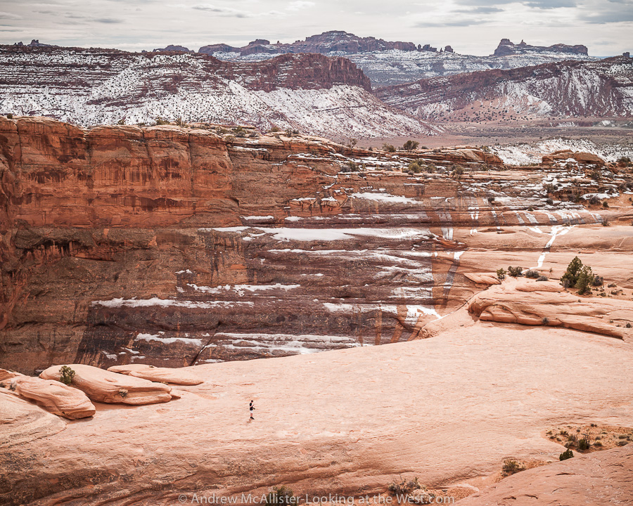
As I was sitting up there on a rock at Delicate Arch, camera anchored to one of my trusty tripods, watching all the people and taking it in. A family with teenage boys approached the Arch and had a little photo session. Mom and Dad hugging under the Arch, Mom with the boys, goofy shots looking like you are pushing the arch, all the usual stuff. One of the teenage boys wandered away from the group and was messing with a phone or iPod. As I watched him I noticed that this was the picture that I wanted to make. Kind of funny to walk up to a world famous site and take a picture that does not include the “famous” thing. It’s a shot, a view, a situation that I had not seen, it spoke to me of being disconnected to the environment. 20130303_Moab Trip_8320

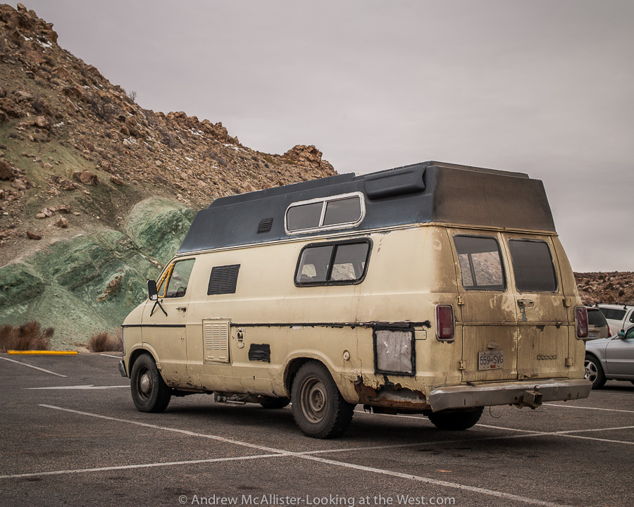
People watching in the National Parks is a great activity as is spotting cool cars in the parking lots. As we concluded the hike and made it to the parking lot the first thing I noticed was this really cool bright red Jeep. Chrome wheels, big tires, winch, fancy bumpers, the works. Easily a $50K ride but with no soul (at least not yet). Parked a short distance was this old Dodge Van. My friends and I gathered around it and inspected it’s scars, rust and dirt. This was not the best ride in the lot but man it has some history. Just looking at it you know it has had some serious adventures.

No Town Utah: Floy revisited

20130209_Floy Utah_014Not all of Southern Utah is Red Rock. The ranch exit of Floy (near Crescent Junction) has a great collection of strange grey lumps that may make you think you are on another planet. I last visited in early February and it was much to muddy to go exploring off the road. The time before it was around 100˚ with no shade. This landscape at the base of the Book Cliff does not fail to inspire.

20130209_Floy Utah_011

20130209_Floy Utah_029

Above: When driving Utah 152 watch your speed. Because the road is empty 99.99% time, it’s tempting to drive in the middle or left side of the road to avoid potholes and rough section. Beware though that the road does have blind areas and would be terrible to have a head on collision in such a remote place (or anywhere). On a technical note these images were shot using Nikon’s 24mm PC-E lens. I’m finding it to be a great lens for the landscapes I’m photographing. Any thoughts on the lens flair in the right corner. Some people like it, I usually get rid of it.

20130209_Floy Utah_008Above: Contrail in the Southern Utah sky.

20130209_Floy Utah_007Above: Open Road at the Floy ranch exit near Crescent Junction. Note the lack of shoulder and no fence so watch out for the wildlife.

Red Rock Country in Blue and Silver

20130209_Utah Scenic Route 128_088Who knew red rock country could look silver and blue? A few images from my first trip to Moab this year (February 2013). All three were taken along Utah Scenic Route 128. It starts near the ghost-town of Cisco and follows the Colorado River into Moab via Professor Valley. The image above is available through Glow Artworks who I starting working with earlier this year.20130209_Utah Scenic Route 128_074It would not be Utah if the landscape did not have some evidence of the gas and oil industry. The facility above is part of a pipeline that runs through the area.

20130209_Utah Scenic Route 128_078Lastly a view into Professor Valley from Utah Scenic Route 128. Close to the center is Fisher Towers, an area not known to look blue. FWIW all 3 images were shot with the spectacular Zeiss 100mm Makro-Planar lens.

Springtime in Northern Utah

20130321_Cache Valley Utah_007As I write this we have had a few weeks of warm weather and much of the snow in the lower half of the images here has melted and the grass has started to grow. Also as I write this a storm is blowing through bringing new snow to higher elevations. It can try but it wont last! Spring and fall are great times if you love weather. I was really tired of the clear and cold weather of January and February. The seasonal weather patterns mixed with the geography of Northern Utah make for visually spectacular scenery. The images above and below from the same morning a few weeks back (March 2013).

20130321_Cache Valley Utah_005

Below: Storm clearing in Cache Vally April 2013. Described by my friend Woody as looking like a “title wave from hell”. I have seen many cool weather systems move across the valley and by the time you get the camera set up it’s usually not as cool as when I first saw it. This one was different and I rushed to capture it. As I took a dozen images over a few minutes it lost it’s shape and became a less than spectacular blob. This was the second or third frame. This weather was the beginning of what we are going through now in Northern Utah. This storm system has been good to me both with this image and with some images I made the next day when I revisited Downey Idaho.

20130405_Cache Valley_8530Top two images captured with the Zeiss 100mm Makro-Planar and the image above with the Nikon 45mm PC-E.


Southern Utah: Ghost Rocks Viewpoint

Hunter Power Plant from Ghost Rock

Above: Huntington Power Plant from Ghost Rocks Viewpoint along I-70 in Southern Utah.

Updated (3/16/13) from Wikipedia “The highway then ascends Ghost Rock Summit, the highest point for I-70 inside the swell. At the summit is another view area overlooking the Little Grand Canyon of the San Rafael River.The summit is named for unusual rock formations nearby. The Ghost Rocks themselves are at 7,405 feet (2,257 m), although the freeway is slightly lower.” Read the whole article on building I-70 through Utah here. 

20130209_Ghost_Rocks_Viewpoint_010

Above: Cloudburst above Castle Valley Utah.

Southern Utah: San Rafael Reef


San Rafael Reef in Southern UtahAbove: I-70 road cut at the San Rafael Reef in Southern Utah. To avoid a snow storm on Soldier Summit I decided to take I-70 for my return route from Moab last month. What a good decision it was. The San Rafael Reef is visible from my usual route (Utah 191 from Price) but I had never been this close. If you are traveling I-70 through this area plan extra time to stop at all of the scenic overlooks, they are well worth it. Taking this route greatly expanded my desire to explore Southern Utah. Expect more information and photos from this amazing part of the state.

San Rafael Reef in Southern Utah
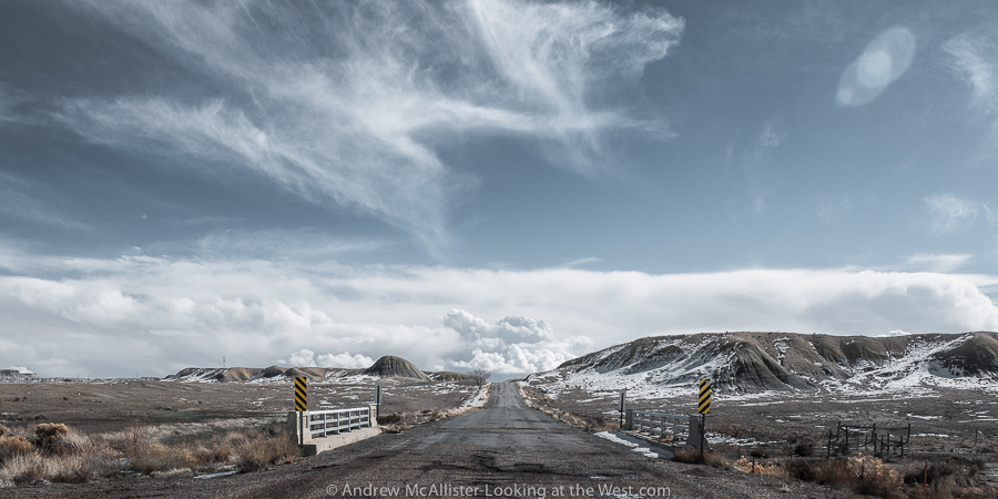
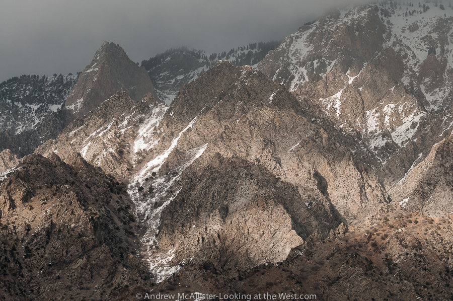
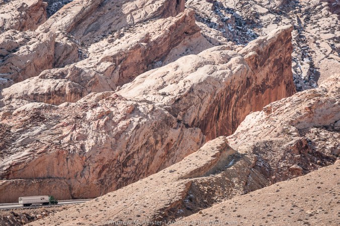
Above: Detail of the road cut at the San Rafael Reef. Didactics at the rest area explain the massive project to widen a slot canyon into the modern highway we travel today.

San Rafael Reef in Southern Utah

Above: I-70 Rest Area at the base of the San Rafael Reef. Photographers would be crazy not to stop.Book Cliffs from the San Rafael Reef in Southern Utah

Above: Looking toward the Book Cliffs from the San Rafael Reef.

How many of you have been to this part of Southern Utah?

Northern Utah: Willard Peak Light and Shadow

Willard Peak in Northern UtahAbove: Dramatic Light and shadow on the base of Willard Peak in Northern Utah. Recently I have expanded my lens set to cover wider and narrower views and so begins the process of learning how these tools effect how I see and how to get the most out of them. The above image form this past weekend was made with the wonderful Zeiss 100 Makro-Planar. I am pleased with the lenses ability at and near infinity, a distance that many of my subjects occupy. Excellent contrast and focus from 1.4 miles distance in the foreground and at 2.23 miles near the top.

Willard Peak

Above: Dramatic light and shadow on the rugged base of Willard Peak in Northern Utah.Willard PeakAbove: Dramatic light and shadow with blue-grey sky and passing cloud cover on the rugged rocky base of Willard Peak in Northern Utah.

Cache Valley Inversion winter 2013

Cache Valley Inversion
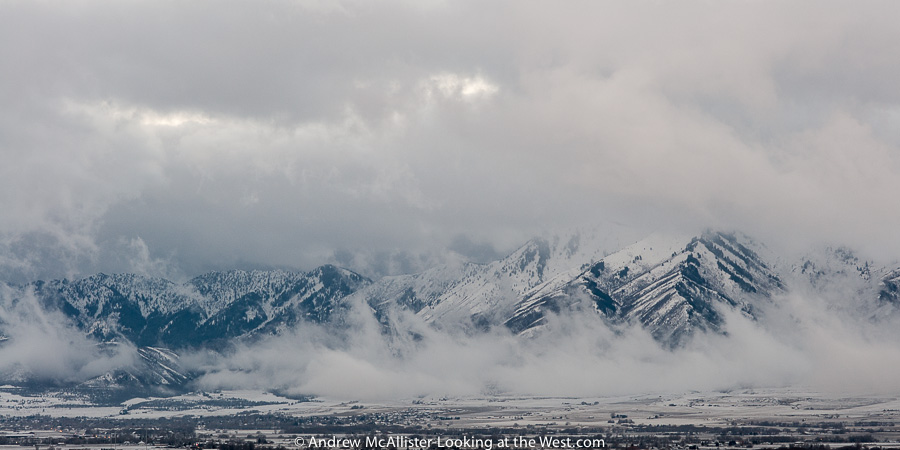
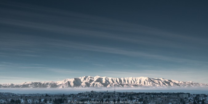
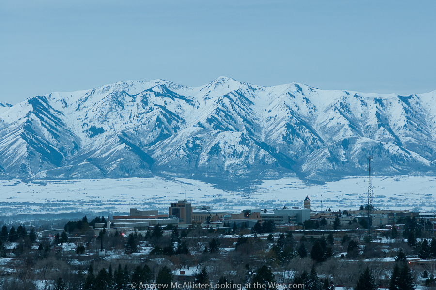
Above: Dramatic view of the Cache Valley Inversion 2/2/13. The inversion continues and like most things looks better or worse depending on the day and the hour. As a newer resident I am shocked at how disgusting the air can be. At times you can taste it in your mouth for 30 minutes after you have come inside. I’m fortunate to live on the bench and am above the thick part of it most of the time. Visually the inversion can be stunning and enjoyable to photograph. I prefer drama to a clear blue sky any day.
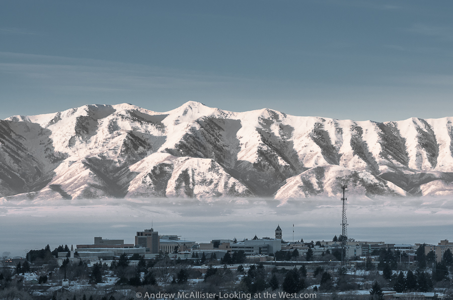
Winter 2013 Inversion Cache Valley Utah

Above: USU and Cache Valley  inversion 2/3/13. A closer view with USU, the Wellsville Range and some pollution in-between. Taken at the beginning of another red air day.

Winter 2013 Inversion Cache Valley Utah

Above: A wider view from the same morning. I really hope that Cache Valley can get a grip on the pollution. I was shocked when I first moved here at the number of diesel pickup trucks that treat every green light like the beginning of a race or some contest to see who can spew the largest cloud of black soot onto the intersection. The pollution problem is large and more complex for sure and I am no expert. It will be interesting to see if Logan and Cache Valley can meet EPA requirements by 2014. If my images or distinct vantage point can be of use to people working on the inversion problem please contact me I’d love to help out.

Cache Valley: Foggy Grey Winter

Photograph of grain silos in dense fog.Above: Grain Silos near Lewiston, Utah on a grey foggy January afternoon in Northern Utah. Depending on the screen you view this on you can see quite a bit. I’m amazed I was able to get sharp focus on the silos. Could be the start of a series of posts on agriculture architecture. There certainly is a lot around the area. Does anyone know the difference (if any) between a silo, grain silo and a grain elevator?