Cache Valley Utah

After the past few posts it’s time for a break from red rocks, blue skys and Toyota Landcruisers. I’ll start with this image from the homestead in Cache Valley looking to Gunsight Peak some 23 miles away.

Storm Clearing in Cache Valley Utah

Storm Clearing in Cache Valley Utah 5/29/2013


Millville Fire 2013

Wildfire dammageWildfire in Cache Valley August 2013. Millville fire burn line looking North toward Logan. Updated info Here: http://inciweb.nwcg.gov/incident/3631/

Millville fire 2013Above: Wildfire scars near Blacksmith Fork Canyon.

tree on fireA detail cropped from the above photo shows a tree starting to burn on Millville face.


Springtime in Northern Utah

20130321_Cache Valley Utah_007As I write this we have had a few weeks of warm weather and much of the snow in the lower half of the images here has melted and the grass has started to grow. Also as I write this a storm is blowing through bringing new snow to higher elevations. It can try but it wont last! Spring and fall are great times if you love weather. I was really tired of the clear and cold weather of January and February. The seasonal weather patterns mixed with the geography of Northern Utah make for visually spectacular scenery. The images above and below from the same morning a few weeks back (March 2013).

20130321_Cache Valley Utah_005

Below: Storm clearing in Cache Vally April 2013. Described by my friend Woody as looking like a “title wave from hell”. I have seen many cool weather systems move across the valley and by the time you get the camera set up it’s usually not as cool as when I first saw it. This one was different and I rushed to capture it. As I took a dozen images over a few minutes it lost it’s shape and became a less than spectacular blob. This was the second or third frame. This weather was the beginning of what we are going through now in Northern Utah. This storm system has been good to me both with this image and with some images I made the next day when I revisited Downey Idaho.

20130405_Cache Valley_8530Top two images captured with the Zeiss 100mm Makro-Planar and the image above with the Nikon 45mm PC-E.


Cache Valley Inversion winter 2013

Cache Valley Inversion
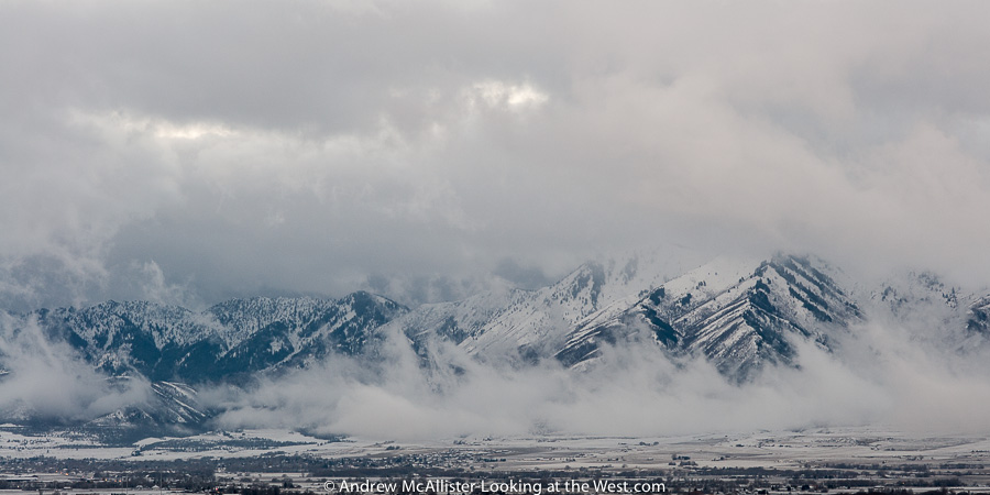
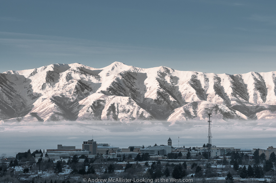
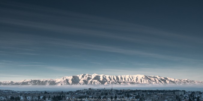
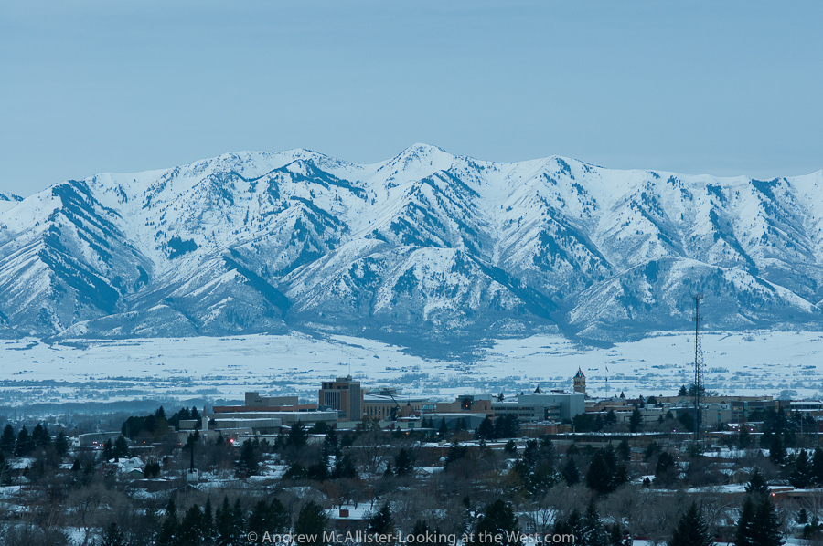
Above: Dramatic view of the Cache Valley Inversion 2/2/13. The inversion continues and like most things looks better or worse depending on the day and the hour. As a newer resident I am shocked at how disgusting the air can be. At times you can taste it in your mouth for 30 minutes after you have come inside. I’m fortunate to live on the bench and am above the thick part of it most of the time. Visually the inversion can be stunning and enjoyable to photograph. I prefer drama to a clear blue sky any day.

Winter 2013 Inversion Cache Valley Utah

Above: USU and Cache Valley  inversion 2/3/13. A closer view with USU, the Wellsville Range and some pollution in-between. Taken at the beginning of another red air day.

Winter 2013 Inversion Cache Valley Utah

Above: A wider view from the same morning. I really hope that Cache Valley can get a grip on the pollution. I was shocked when I first moved here at the number of diesel pickup trucks that treat every green light like the beginning of a race or some contest to see who can spew the largest cloud of black soot onto the intersection. The pollution problem is large and more complex for sure and I am no expert. It will be interesting to see if Logan and Cache Valley can meet EPA requirements by 2014. If my images or distinct vantage point can be of use to people working on the inversion problem please contact me I’d love to help out.

Cache Valley: Foggy Grey Winter

Photograph of grain silos in dense fog.Above: Grain Silos near Lewiston, Utah on a grey foggy January afternoon in Northern Utah. Depending on the screen you view this on you can see quite a bit. I’m amazed I was able to get sharp focus on the silos. Could be the start of a series of posts on agriculture architecture. There certainly is a lot around the area. Does anyone know the difference (if any) between a silo, grain silo and a grain elevator?

Red Rock Pass

Researching one of my favorite areas in Cache Valley (Bear River Narrows) I came across Red Rock Pass. It is at the northern most end of the valley and the site of the cataclysmic event that partially drained the ancient Lake Bonneville. Located about an hour north of Logan, it is one of my favorite new places. The hazy light really brought out the red colors in the rock.

Looking South toward Caribou National Forest. The white on the poles is wind blown snow from earlier in the day.

The above shot looks at the western side of Red Rock Pass. The large hole above the corral looks like a mouth, above it an upturned nose and eyes. My lens could not fit the entire scene in so this is stitched from 5 exposures. On this first trip we returned to Logan via 15 South, took the first exit (Utah 36) Deep Creek Road and Weston Canyon. See my post Rolling Hills for a view of that area.

A few days later the weather improved and I headed up to Red Rock Pass to photograph the area in better light. Above view from the bend in the road. Very different light than the first visit. Stronger contrast and feel for the height but loses the subtle colors of the hazy image. This time I took S Back Red Rock Road and photographed the power transmission lines that I had seen on the first visit. Below view looking south across Red Rock Pass. The power poles below that look like giant pins are double circuit 345 kV lines.

With clearer skys to the North I traveled a short distance to Downey Idaho explored the small town on foot until it was dark. I returned to Red Rock Pass on my way back to Logan. Hoping for a patch of clear sky to illuminate the area as it was full moon. As I waited a short time before bailing do to it being cold, very windy and very creepy. Put it on the list of places to revisit in different weather. Definitely worth the effort to exit I15 drive and drive a few miles to check this location out if you are in the area.

Grain Elevator, Preston Idaho

One of my first excursions when I moved to Cache Valley was a visit to Preston, Idaho. A famous place here in the valley as it was the setting for the film Napoleon Dynamite. Upon arrival from the south one of the first things you see is a large grey tin sided grain elevator. I liked this one because it looked so humble. Logan has a few and they look somewhat industrial though at a much smaller scale than those seen on I-15 in Ogden. In the afternoon, the time I’m usually in Preston, the grain elevator is back lit and thus I had not photographed it on my first few visits. This past January I was testing a perspective control lens that I had rented for a job and thought this grain elevator would make a great subject. A little over a month later the grain elevator caught fire.

Video clip linked from Youtube user hullhollyjo.

Technical info: Top image captured with the Nikon D300s and 24mm PC-E lens (from Borrowlenses.com), post fire images D300s and 45mm PC-E lens. Processed in Adobe Lightroom 4.

Exploring Cache Valley

Cutler Dam area, Cache Valley Utah. Taking advantage of a winter storm that was blowing into Northern Utah I revisited some areas that could benefit from some drama in the sky. Between Gunsight Peak and the northern end of the Wellsville Mountains is an area with dramatic cliffs with velvety hills and washes. The landscape of this area has fascinated me since moving to Cache Valley. Unseen from this view is a large dam and power plant tucked between the cliff and the river. The area has walk-in access for hunters, I need to find out if I could walk-in for photography or wildlife observation. If not maybe I could get a hunting license, register to walk-in and then “hunt” for photos and “shoot” them. Until then I’ll respect private property and stay on the road.

Technical info: Images captured with a Nikon D300s and 45mm PC-E lens and processed in Lightroom 4.

Soundtrack for gloomy weather photography: Crime and the City Solution and Nick Cave and the Badseeds.