Springtime in Northern Utah

20130321_Cache Valley Utah_007As I write this we have had a few weeks of warm weather and much of the snow in the lower half of the images here has melted and the grass has started to grow. Also as I write this a storm is blowing through bringing new snow to higher elevations. It can try but it wont last! Spring and fall are great times if you love weather. I was really tired of the clear and cold weather of January and February. The seasonal weather patterns mixed with the geography of Northern Utah make for visually spectacular scenery. The images above and below from the same morning a few weeks back (March 2013).

20130321_Cache Valley Utah_005

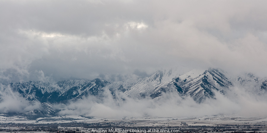
Below: Storm clearing in Cache Vally April 2013. Described by my friend Woody as looking like a “title wave from hell”. I have seen many cool weather systems move across the valley and by the time you get the camera set up it’s usually not as cool as when I first saw it. This one was different and I rushed to capture it. As I took a dozen images over a few minutes it lost it’s shape and became a less than spectacular blob. This was the second or third frame. This weather was the beginning of what we are going through now in Northern Utah. This storm system has been good to me both with this image and with some images I made the next day when I revisited Downey Idaho.

20130405_Cache Valley_8530Top two images captured with the Zeiss 100mm Makro-Planar and the image above with the Nikon 45mm PC-E.


Out of my comfort zone with fall color

Fall color, Blacksmith Fork Canyon in Northern Utah

I have a history with looking up in my photography that started a dozen or so years ago when my friend Jason Byers encouraged me to get closer and exaggerate the perspective of Cleveland skyscrapers. As a result my approach to large objects has always had two competing views. One that says step as far back as necessary to make absolutely sure the perspective is correct and the other that says get too close and look up. To get the perspective correct I use a tilt and shift lens when possible and correct perspective in photoshop for images taken with non PC lenses. For years I have been very comfortable with the way I see the world and what I want to photograph in it. Lately I have been experimenting with selective focus via tilting the lens as a way to creatively stretch they way I look at things. The images in this post a outside of my comfort zone photographically in two ways, one being that I don’t shoot fall color landscapes. They have not been of interest until I moved to Utah and I’m still not sure what I think beyond the color. The second thing that takes me out of my comfort zone is the play of focus. The lens tilt makes things look as if the are miniature and is best accomplished by looking down on the subject. However with the above shot I am clearly looking up. I enjoy the confusion that it causes. The western landscapes is huge and are always photographed to emphasize the size. However this stretch of mine is forcing these huge thing to appear way smaller than they are and thus subvert their western-ness.

Below is a more traditional angle of view using the tilt effect. Most photographers are aware that these effects can be accomplished in newer versions of Photoshop and many iOS apps however I personally would recommend using the lens itself. There is something about committing to the focus area you are interested in and locking that in the RAW file that gives the stretch impact. The lenses are available to rent from Borrow Lenses dot com and Lens Rentals dot com. 

Fall color, Logan Canyon in Northern Utah

Northern Utah: Fall Color

Fall color is in full swing here in Utah. Hope everyone is out enjoying it, I know I am. Last year I missed most of it due to travel so this is my first real Utah fall. It is amazing! In the coming weeks I’ll be posting more fall color, images from the Tetons, another Moab trip and an entirely new series. Hope to get things caught up before it starts snowing. Have fun exploring your world!

Exploring high places: Logan Peak Summer 2012

After a year living in Logan I had the opportunity to drive up to Logan Peak (elevation 9710) this past June with my friend Carston and wow, what a drive it is. As with most drives in the Wasatch-Cache National Forest all but a few sections can be handled with a normal all wheel drive car and competent driver. In this case we passed a Honda Element (not high clearance vehicle) a mile or so from the top and it really was not until the last 100 yard that I had to put the Xterra into 4-wheel low. If you live in the area you should give it a visit sometime. The fastest route is via Logan Canyon and Right Hand Fork. From there go up Crowley Canyon (Forest Route 047) at the junction go west on 052. The next major turn is at White Bedground Camp with the way to Logan Peak well marked (Forest Route 168). This stretch of road goes through a really nice and well developed Aspen grove, has some fun switchbacks and a nice climb at the end where there is a parking area. At this point you will stay left on a nicely graded section of road, not the steep and rocky side trail to the right. The trail stays relatively flat until the last turn onto Forest Route 042. A mile or so later you will be there. This last section I would not attempt in a normal street clearance vehicle as there is a short rocky section that may stop you and the last section before the radio tower that will stop you for sure, plus it would be a pain in the ass to back out. The roads in the area close November 15 or earlier depending on winter weather.

Above: View from the top looking East. The road is Forest Route 042. As a side note the day we drove up there was a race and the road was packed with runners and mountain bikers.

Above: Last bits of snow hanging on.

Above: Looking North West from Logan Peak June 2012. These photos give an idea of the place and I would consider them location scout shots. The views would really be stunning on a cool fall morning at first light. I guess that means I have a return trip in the coming months. Yeah! One final note, access to Logan Peak via Providence Canyon was closed as of June 2012 to vehicles (Impassable). If you plan on visiting via that route check with the ranger station to confirm that Forest Route 090 is open.

Exploring around Moab: Fisher Towers

On our last trip to Moab we decided to not just take 191 south from Cresent Junction but instead go north of I-70 and do some exploring in the Book Cliffs and Sego Canyon. That part of the adventure ended in the (almost) ghost  town of Thompson Utah and the next part would be the Colorado River Scenic Byway. A pullout near Fisher Towers would be the location of a quick road side dinner and some creative photography. Recently I have become interested in the technique of tilting the camera lens for artistic and technical effects. Most of the examples I have seen are of city or industrial scenes so I thought I would try it out on some southern Utah landscapes. Above: Fisher towers. Below: Mesa near Fisher Towers with tilt blur effect.

Below: Fisher towers with with tilt blur effect on the sky and the top of the red rock.

Below: Road into Moab (128) with tilt blur effect. It takes some practice using the lens in the field and getting the effect where you want it. The look is easily faked in Photoshop, for me though it is way more interesting to think about and apply the technique in camera.

Exploring Canyonlands: Needles Overlook

After our trip to Beef Basin we decided to check out the needles overlook before returning to Moab. As luck would have it we were the only ones there. Even though the wind had kicked up lots of dust making the view  very hazy the Needles Overlook was no less stunning. Sometime I’ll have to stay at the camp ground a few miles from here and photograph this area early morning light. I’m sure it is spectacular.

Below: Looking toward the needles district. In the distance you can see Cathedral Butte (on the right).

Below: Views form the Needles Overlook are stunning even in hazy conditions. I wonder how many lens caps and hats you could find at the base of the cliff. Strong wind can seemingly come out of nowhere and the fence is welcomed. I don’t generally have a fear of heights but this overlook had me holding the railing more than once.

Below: Be where you are. As a photographer visiting such a spectacular location it can be tempting to just get into a zone and photograph like mad. My wife taught me the saying “be where you are” and I keep it in mind when out exploring our world. Taking photographs is a major part of my experience to be sure, however I do take time in-between shots to stop and take things in. The smell of Juniper and the sound wind blowing through evergreen are some of my favorites. Watching birds in the updrafts around the cliffs is another. If you just take pictures the whole time have you really experienced the place or is it just a photo location? 

Wheelon Utah at dusk

Northern Utah landscape near the Bear River Narrows at Wheelon. The small road in the image follows an irrigation canal on the east side of the Bear River (out of frame on the right). I’m attracted to the contrast between the natural roll of the gullies and the hard cuts of the man made canal.

Looking at: Downey Idaho

Downtown Downey Idaho April 2012. Two classic brick structures define the main intersection of this small farming town (population 613) in southern Idaho.

Old Downey Theater sign says “opening soon Laurel and Hardies.” The two story structure is called Hyde Block and it houses the town’s market It features an ad for Mountaineer Overalls with Stop Loss pockets.

The best image from the shoot includes a dilapidated two-story building, a grain elevator, a bar with a log cabin facade, and a variety of other single-story buildings.

Cunningham Implement and Downey Lumber bathed in orange street light.

Exploring Cache Valley

Cutler Dam area, Cache Valley Utah. Taking advantage of a winter storm that was blowing into Northern Utah I revisited some areas that could benefit from some drama in the sky. Between Gunsight Peak and the northern end of the Wellsville Mountains is an area with dramatic cliffs with velvety hills and washes. The landscape of this area has fascinated me since moving to Cache Valley. Unseen from this view is a large dam and power plant tucked between the cliff and the river. The area has walk-in access for hunters, I need to find out if I could walk-in for photography or wildlife observation. If not maybe I could get a hunting license, register to walk-in and then “hunt” for photos and “shoot” them. Until then I’ll respect private property and stay on the road.

Technical info: Images captured with a Nikon D300s and 45mm PC-E lens and processed in Lightroom 4.

Soundtrack for gloomy weather photography: Crime and the City Solution and Nick Cave and the Badseeds.